
Another in a series of posts looking at patterns of land use and agriculture, thanks to the aerial photography available from Google maps. In this post, a number of photos of agricultural land patterns from around the world. I don't know much about any of these other than seeing the patterns and wondering what combination of crops, irrigation, tradition, use, etc. creates the sometimes radical, sometimes subtle changes from one field to the next.

field patterns, Japan
Above, fields of very different crops, in Japan, carefully and precisely defined in one direction, with variability in the other direction.

field patterns, India
Above, in India, pastures dotted with the occasional perimeter tree. Probably the same kinds of plant species, but within that there are fine variations of color that result from slightly different intensities of use, irrigation, etc.
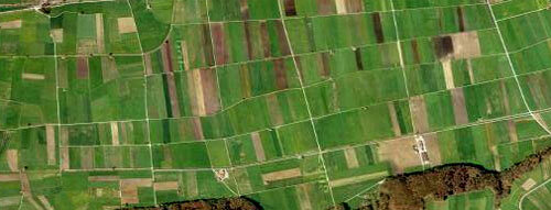
field patterns, Switzerland
Above, in Switzerland, neat and organized.

field patterns, Vietnam
Above, in Vietnam, subtle gradations betweens fields, maybe of all the same crops with only slight differences.

land patterns, Mississippi
Above, in Mississippi. This is not agriculture, but rather some strange road and development pattern, like little pea tendrils spreading out without regard to fields, woods, etc.
If you have any thoughts or knowledge about what makes these patterns the way they are, drop me a line.